Watershed Assessment Projects
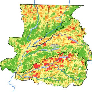
The Tenmile Watershed was selected in 2017 for a special Pilot Watershed Assessment Project as part of the NRCS National Water Quality Initiative (NWQI). The NWQI program aims to implement voluntary conservation practices to improve water quality in high-priority watersheds while maintaining agricultural productivity. This watershed assessment was an exercise in characterizing and identifying the land uses, or “critical source areas”, that have the greatest potential for nutrient (nitrogen and phosphorous), sediment, and/or pathogen impacts to water quality, while also identifying the outreach strategy and conservation management practices that can be implemented to reduce those impacts.
The project conducted a thorough land use survey and modeling effort to evaluate the highest priority areas for water quality impairment and conservation practice effectiveness. Additional landowner social survey and outreach work was conducted to evaluate water quality perceptions, practice implementation and barriers, and successful information sources to create a comprehensive outreach plan for the watershed.
A full report on the Tenmile watershed assessment can be found HERE.The full Tenmile watershed outreach report can be found HERE.Two more NWQI Watershed Assessments were conducted in 2020 with the same goal of identifying critical sources areas in the Wiser Lake Creek and Fishtrap watersheds and developing a functional outreach strategy to work with landowners.
A full report on the Fishtrap Watershed Assessment and outreach strategy can he found HERE.A full report on the Wiser Lake Creek Watershed Assessment and outreach strategy can he found HERE.